|
|
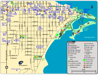
Escanaba Map (Online version)
Escanaba Map (PDF)
Parks shown: Ludington Park, Aronson Island, Royce Park, and Veteran's Park.
Trails shown: Paved trails at Ludington Park and Aronson Island; path along 1st Avenue.
Boat launch shown: The boat launch at Aronson Island.
Historic Locations & Markers: House of Ludington Hotel (1864), Sand Point Lighthouse (1867), First United Methodist Church (1907), Bethany Lutheran Church (1912), Hereford & Hops Steakhouse Building (1914),St. Joseph & St. Patrick Catholic Church (1938), William Bonifas Fine Arts Center (1938). There is a historical marker for Little Bay De Noc at Ludington Park.
Other locations: Escanaba City Hall & Library, Chamber of Commerce, Delta County Courthouse, Civic Center, Escanaba Country Club, Senior Citizens Center, William Bonifas Fine Arts Center, Farmers Market, restaurants, schools, stores and more.
|

|
|
|
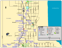
Northern Escanaba Map (Online version)
Northern Escanaba Map (PDF)
Parks shown: Rose Park, Stephenson Park, and Webster Park.
Other locations shown: Catherine Bonifas Civic Center, Senior Citizen's Center, Upper Peninsula State Fair, Willow Creek Cinema 8, restaurants, stores, and more.
|