|
|
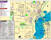
Montague MapTrails included: The Medberry Bike Trail is a paved trail that passes through Montague. The trail connects to the Hart-Montague Trail State Park near the Trailway Campground.
Parks shown: Cullen Memorial Little League Fields, Maple Grove Park (Maple Beach), Montague Band Shell, Montague Township Park, Roesler Lakefront Park, and White River Wetlands Park in Montague. Parks in Whitehall shown on the map are Covell Park, Goodrich Park, and Lions Park.
Also shows the locations of Trailway Campground, White Lake Area Chamber of Commerce, Montague City Museum, Caboose Museum, marinas, boat launches, restaurants, stores, historic locations, museum, schools, churches, scenic views, fishing spots, and more in Montague, Michigan.
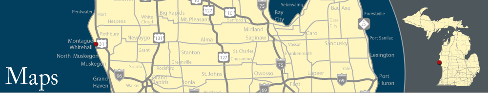
Maps of Montague and Whitehall, MichiganView maps of beaches, parks, trails, boat launches, historic locations, restaurants, hotels, stores, and more around Montague and Whitehall, Michigan, by clicking a link for the online version (GIF) and PDF version. PDF versions are full-page maps, saved at a higher resolution for printing.
|
|
Montague Map (Online version)
Montague Map (PDF)
Trails included: The Medberry Bike Trail is a paved trail that passes through Montague. The trail connects to the Hart-Montague Trail State Park near the Trailway Campground.
Parks shown: Cullen Memorial Little League Fields, Maple Grove Park (Maple Beach), Montague Band Shell, Montague Township Park, Roesler Lakefront Park, and White River Wetlands Park in Montague. Parks in Whitehall shown on the map are Covell Park, Goodrich Park, and Lions Park.
Also shows the locations of Trailway Campground, White Lake Area Chamber of Commerce, Montague City Museum, Caboose Museum, marinas, boat launches, restaurants, stores, historic locations, museum, schools, churches, scenic views, fishing spots, and more in Montague, Michigan.
|

|

|
|
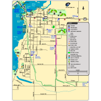
Whitehall Map (Online version)
Whitehall Map (PDF)
Trails included: Part of the White Lake Pathway is shown. The paved trail is used for walking, jogging and biking.
Parks in Whitehall include Covell Park, Funnell Field, Gee Park, Goodrich Park, Lions Park, Millpond Park, Norman Park, Slocum Park, Svenson Park, and White Lake Marina. There is a sledding hill on Hanson Street that is popular during the winter.
The map shows Howmet Playhouse, Caboose Museum, White Lake Area Chamber of Commerce, restaurants, stores, churches, schools, historic locations, marinas, boat launches, and more in the Whitehall area. Shows the locations of Best Western, Ramada Inn, and Super 8 Motel.
|
|
|
|
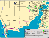
Montague & White Hall Area Map (Online version)
Montague & White Hall Area Map (PDF)
Trails included: The Medberry Bike Trail is a paved trail that passes through Montague. The White Lake Pathway is a paved trail that goes through Whitehall. Both of these trails connect to the Hart-Montague Trail. The trailhead for the Hart-Montague Trail State Park is located near the Trailway Campground.
Bike route included: Cyclists can ride on bike lanes and along the outer edge of a road to reach Medberry Park. The bike route goes along Whitbeck Road to Old Channel Trail and then to Lau Road.
Parks shown: Medberry Park has a nice beach on Lake Michigan. Maple Grove Park (Maple Beach) has a beach on White Lake. Parks in Montague include Cullen Memorial Little League Fields, and Montague Township Park, Roesler Lakefront Park. Parks in Whitehall include Covell Park, Goodrich Park, Lions Park, Norman Park, and Svenson Park.
Also the map shows the boat launch and lighthouse located near Medberry Park.
|
|
|
|
White Lake Pathway Map (Online version)
White Lake Pathway Map (PDF)
The White Lake Pathway is a paved trail that goes through Whitehall. The paved trail is used for walking, jogging and biking. The White Lake Pathway connects to the Hart-Montague Trail State Park near Business US-31.
|
Also see:
- Hart-Montague Trail State Park
|
|