
Attractions
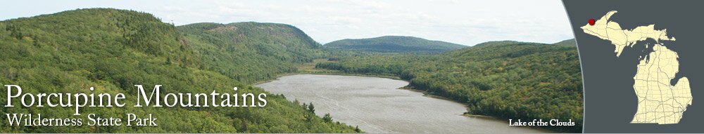
Lake of the Clouds is one of the most photographed state park locations in Michigan. The scenic viewing area is accessible from a short walking path and a wheelchair-accessible boardwalk. The panoramic views of the Lake of the Clouds and the nearby mountains are beautiful, especially in the fall when the leaves are changing colors. There is a comfort station with restrooms on the south side of the parking lot.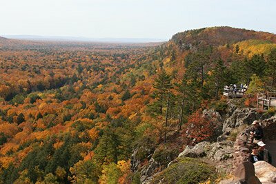
Summit Peak is the tallest point in the park at 1946 feet above sea level. From the parking area, it is a half-mile hike to a combination of stairs and boardwalks that lead to a scenic viewing platform and an observation tower. The panoramic views allow you to see Lake Superior, the Copper Peak Ski Jump near Ironwood, and much more. There are restrooms near the parking area for Summit Peak, near the Summit Peak Trail trailhead.
There are many waterfalls located in the Porcupine Mountains. On the west side of the park, Manabezho Falls, Manido Falls and Nawadha Falls can be seen from a hiking trail and boardwalk. Bathtub Falls and Shining Cloud Falls can be seen from the Big Carp River Trail. Overlooked Falls and Greenstone Falls can be seen from the Cross Trail. Trap Falls can be viewed from the Government Peak Trail, and on the southeast corner of the park, Nonesuch Falls can be seen from a short hiking trail.
Trails
There are over 100 miles of hiking and cross-country skiing trails that meander through the wilderness. Be aware that the trails in the Porcupine Mountains can be steep at times. The Lake Superior Trail is the longest at 17 miles long. The Government Peak Trail is a popular route and is 7.30 miles long.There are over several miles of mountain biking and cross-country skiing trails on the northeast part of the park. You can combine the trail loops for longer rides.
The following unpaved trails are located in the Porcupine Mountains:
- Beaver Creek Trail (1.20 miles): cross-country skiing, hiking
- Big Carp River Trail (9.60 miles): cross-country skiing, hiking
- Correction Line Trail (7.30 miles): cross-country skiing, hiking
- Deer Yard Trail (5 miles): cross-country skiing, biking
- Double Trail (3 miles): biking, cross-country skiing
- East and West Vista Trail (2.50 miles): biking, cross-country skiing
- Escarpment Trail (4.30 miles): cross-country skiing, hiking
- Government Peak Trail (7.30 miles): cross-country skiing, hiking
- Lake Superior Trail (17.10 miles): cross-country skiing, hiking
- Lily Pond Trail (2.50 Miles): cross-country skiing, hiking
- Log Camp Trail (5.00 miles): biking, cross-country skiing
- Lost Lake Trail (3.40 miles): cross-country skiing, hiking
- Nonesuch Trail (3 miles): biking, cross-country skiing
- North Mirror Lake Trail (3.80 miles): cross-country skiing, hiking
- Overlook Trail (2.70 miles): cross-country skiing, hiking
- Pinkerton Trail (2.60 miles): cross-country skiing, hiking
- River Trail (10.50 miles): biking, cross-country skiing
- South Mirror Lake Trail (3 miles): cross-country skiing, hiking
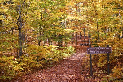
- Summit Peak Tower Trail: (0.50 miles): cross-country skiing, hiking
- Superior Loop (1.50 miles): biking, cross-country skiing
- Triple Trail (3 miles): biking, cross-country skiing
- Union Mine Trail (1 mile): cross-country skiing, hiking
- Union Spring Trail (4 miles): biking, cross-country skiing
- Visitor Center Nature Trail (1.40 miles): cross-country skiing, hiking
- Whitetail Path (0.80 mile): cross-country skiing, hiking
Bike Routes
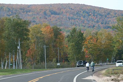
Using the paved shoulder along 107th Engineers Memorial Highway, cyclists can ride between Silver City and the Porcupine Mountains. The three mile route offers a few views of Lake Superior. When you're riding from Silver City, the Porcupine Mountains will part of your scenery.It is approximately 8 miles from the visitors center to the Lake of the Clouds. The bike route to the Lake of the Clouds has some steep hills.
Fishing
There are miles of rivers and creeks inside the state park where you cast your fishing lines. You will need to use a hiking trail to most of the locations since there is not parking nearby. The trails best-suited for fishing are the Big Carp River, Lily Pond Trail, and South Mirror Lake Trail.A valid fishing license is required to fish on Michigan lakes and waterways, and you can get a Michigan fishing license online at the Michigan DNR E-License web site and at bait shops and sporting goods stores.
Camping
Porcupine Mountains Wilderness State Park has one modern campground, several rustic campgrounds, yurts, rustic cabins, and backpack camping sites.The Union Bay Campground is not far from Lake Superior on the north side of the park. The campground has 100 modern camping sites with electrical service and modern restrooms.
Visit the Michigan DNR reservation web site or call (800)447-2757 to make a camping reservation. The DNR's Porcupine Mountains web site has prices and more information about camping.
Other Lodging
Three miles from from the Porcupine Mountains in Silver City, you'll find AmericInn. The nice hotel is along M-64, a short walk from Lake Superior.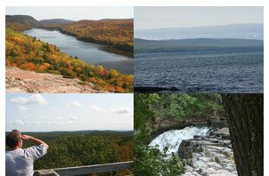


|
|