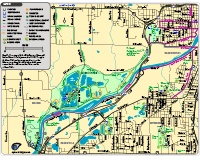
Wyoming Map (Online version)
Wyoming Map (PDF)
Parks included: Hillcroft Park, Klingman's Park, Lamar Park, Pinery Park, and Veteran's Memorial Park.
Trails included: Pinery Park and Lamar Park have paved trails for walking and jogging.
Bike Route shown: The bike route connects to Kent Trails west of Byron Center Avenue. When using the bike route, ride on the outside of the lane in the same direction as cars.
Map also shows the locations of the library, stores, restaurants and more.
|
Southern Wyoming Map (Online version)
Southern Wyoming Map (PDF)
Parks included: Buck Creek Nature Preserve, Charles Lemery Park, Frog Hollow, Gezon Park, Ideal Park, Kelloggsville Park, Oriole Park, and Palmer Park.
Trails shown: A paved trail extends from Charles Lemery Park to Buck Creek Nature Preserve. The trail/bike route that starts near 60th Street, west of S Division Avenue, goes north and then west to connect to Kent Trails. The M-6 Trail is just south of Frog Hollow Park.
Map also shows the locations of attractions, stores, restaurants, golf courses, and more.
|