Grosse Ile Map
Download the higher resolution PDF version:
Grosse Ile Map (PDF)
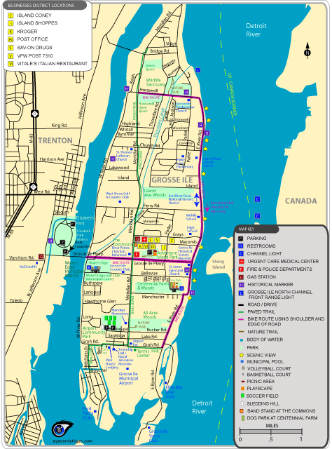
Parks shown: Adventure Island Park, Airport Community Park, Centennial Farm, The Commons, Cortis Park, Elizabeth Park Marina, Water's Edge Golf Club, Water's Edge Marina, and several green spaces.
Trails shown: A wide paved trail for biking, walking, jogging and roller-blading is located along Meridian Road, Groh Road, and South Pointe Road. There are short nature trails at 80 Acre Woods, Adventure Island Park, and Grosse Ile Wildlife Sanctuary.
Bike Routes: Much of East River Road has a wide shoulder on the west side of the street for southbound riding; you'll need to ride along the edge of the road in other spots. If you ride north on East River Road, you'll need to ride near the outside edge of the street. No matter which direction you ride on East River Ride, you'll have a scenic ride near the Detroit River. To reach the paved trail from East River Road, you can ride on the outside edge of Horesemill Road.
You can ride east or west using the paved shoulder along Grosse Ile Parkway. If you need to cross the bridge to reach Trenton, it's best that you walk your bike on the bridge's sidewalk until you reach the end.
Boat Launch: There are multiple boat launch ramps at Elizabeth Park Marina.
Other locations: Grosse Ile North Channel Lighthouse, Grosse Isle Tennis Center, Grosse Ile Township Hall, Grosse Ile Historical Society, Naval Air Station Museum, schools, post office, golf courses, stores, restaurants, churches, historic locations, and more.