|
|
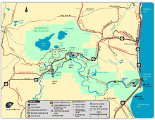
Tahquamenon Falls State Park Area Map (Online version)
Tahquamenon Falls State Park Area Map (PDF)
Full view of the state park, includes Upper Tahquamenon Falls, Lower Tahquamenon Falls, boat launches, fishing spots, gas stations, Paradise, and more.
Trails included: North Country Trail, Tahquamenon River Trail, Clark Lake Loop, Giant Pines Loop, Wilderness Loop, and snowmobile trails. Also shows part of the Bike Route to Whitefish Point along M-123.
|

|
|
|
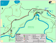
Zoomed-in Map of Tahquamenon Falls State Park (Online version)
Zoomed-in Map of Tahquamenon Falls State Park (PDF)
A closer view of the park that includes the locations of the Tahquamenon Upper and Lower Falls, Tahquamenon Falls Brewery and Pub, hiking trails, campgrounds, and snowmobile trails.
Trails included: North Country Trail, Tahquamenon River Trail, Clark Lake Loop, Giant Pines Loop, part of the Wilderness Loop, and part of a snowmobile trail. The Giant Pines Trail loop can be used for cross-country skiing.
The Tahquamenon Brewery & Pub is located at the Upper Falls area in the Camp 33 Building.
|